@ SAMS, Science + Autonomy = Answers


-
 Dr Phil Anderson and his kayak. Photo from SAMS.
-
 SAMS’ Gavia’s are used on a wide range of missions. Photo from SAMS.
-
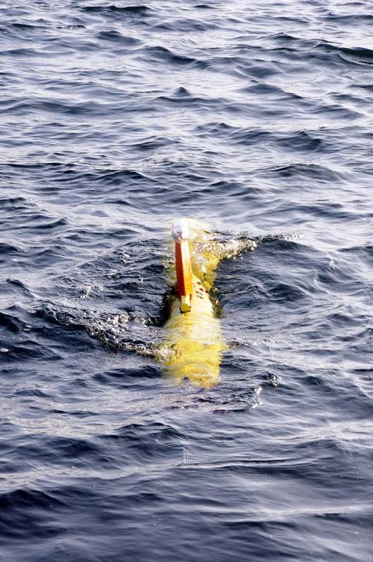
 Gliders have become a regularly used platform for ocean monitoring. Photo from SAMS.


Few sea and ocean-related research projects today do not involve some form of underwater robotic or marine autonomous system. Elaine Maslin reports on how they’re being used by the Scottish Association of Marine Science.
Whether it’s large autonomous underwater vehicles (AUVs), remotely operated vehicles (ROVs), gliders, landers, small man-portable AUV systems and even air-borne vehicles, unmanned systems have become a day-to-day tool. And, while ready built systems are now readily available, easy access to components is enabling researchers to assemble bespoke platforms to meet specific research needs.
The result is that the reach and resolution of the data marine science research is able to gather is being extended. The work done by the Scottish Association of Marine Science (SAMS) is a case in point. It’s a charitable organisation, with its roots in the 1800s, that does a lot more than its remote location on the wet and crinkly west coast of Scotland might suggest. It’s involved in projects on a global stage and there are few areas of the seas and oceans that it’s not been at least some studies in; from looking at the survivability of prawn catch discards to the behaviour of the Atlantic Meridional Overturning Circulation (AMOC) and its influence global climate patterns.
SAMS has a fleet of vehicles to aid its work. In fact, 2019 marked 10 years since it first used a glider, a Seaglider named Talisker, which was most recently deployed off the Western Isles of Scotland to listen for whales. To date (or up to when I visited in October 2019), SAMS had deployed 19 different gliders, completing – in total – 38 missions over 4201 days, covering 68,238 km. Talisker itself has logged more than 12,000 km and is joined by two other Seagliders: Ardbed and Corryvreckan.
SAMS’ fleet includes ROVs, AUVs and gliders, as well as unmanned aerial vehicles (UAV/drones) and even vehicles it’s built itself.
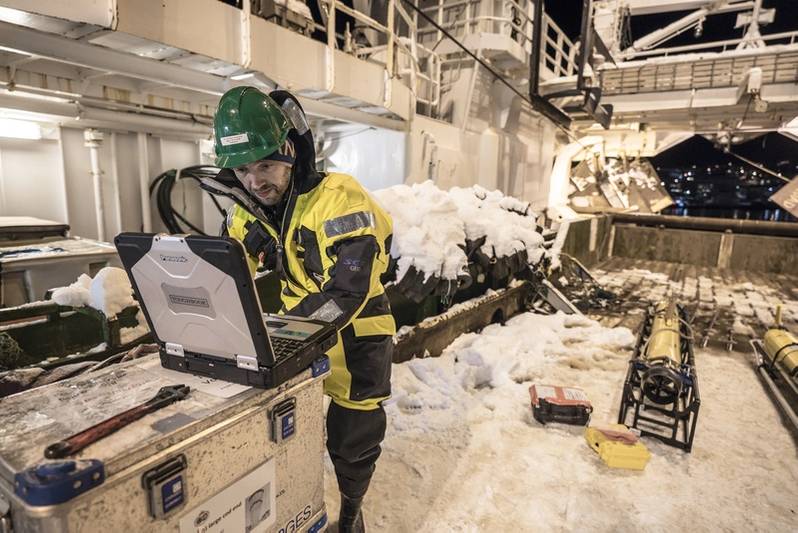 Work in the snowy, 24-hour night of the Norwegian arctic. Photo by Michael O. Snyder.
Monitoring arctic ecosystems
These platforms are enabling data gathering previously too expensive or difficult to do before. For example, Professor Finlo Cottier and Dr Marie Porter from SAMS have been leading the Arctic PRIZE project. It’s not actually a prize. PRIZE stands for “productivity in the ice zone”. Specifically, it’s the productivity of phytoplankton. These creatures tend to bloom every spring – kick-starting the eco-system after winter. But, what sparks the bloom, when, its extent and how this is impacted by changes in shrinking seasonal sea ice coverage isn’t that well understood.
That’s because monitoring arctic areas during cold dark winters isn’t easy, so data is sparse and usually only obtained in summer. In 2018, SAMS was part of a group that looked to change that. It went into the Norwegian arctic Barents Sea in January (24-hour darkness), April and July (24-hour daylight) - something no one had done in that area in a single year - to gather data on cruises using research vessels (the University of Tromsø’s Helmer Hanssen and British Antarctic Survey’s RRS James Clark Ross). To fill multi-month-long gaps between the cruises and overlapping with the cruises, G2 Slocum gliders were deployed. The Slocum used is part of the UK’s Marine Autonomous & Robotics Systems (MARS) pool and can dive to 200m deep.
With support from modelling, the scientists were able to place the Slocum in the right place at the right time when the algal bloom started. The vehicle’s sensors detect chlorophyll proxies (sending out light and detecting the change in wavelength of the return to detect what’s there/fluorometer). These went from “just above background level to almost off the chart about three days and saw how it moved,” says Dr Porter. As well as the phytoplankton detections, the vehicle also measures other parameters: temperature, salinity, dissolved oxygen, depth, average current, and ambient light so scientists can try to understand the wider picture.
“That’s where robotics are really good,” says Prof Cottier. “They’re limited by batteries but are very useful, so there’s desire to use them more in these areas, especially in difficult (seasonal) windows.”
But, there’re trade-offs. How much instrumentation you take limits mission length due to battery capacity. What’s more, in arctic waters, the freezing temperatures also drain batteries faster than in warmer waters, points out Dr Porter. With few recovery options in the area – the nearest port being 24 vessel steaming hours away – the project had to balance risk too. And, working in ice-strewn areas, there had to be close attention to the possibility of fresh water, from melting ice, which would impact the buoyancy driven vehicle’s performance, and the potential for the vehicle to get stuck under ice, which can move quicker, driven by ice, on the sea surface than the vehicle itself. There are also underwater currents, driven by the bathymetry, to be wary of.
The result is a better understanding of the algal blooms. With these data, the team can now work with data gathered over 20 years by Norwegian organisations to inform models and predictions of what could happen in future years. Another project, the Nansen project, now started in Norway, will also look to pick up the monitoring mantle.
 SAMS’ Gavia’s are used on a wide range of missions. Photo from SAMS.
The listening project
Another SAMS project is COMPASS (Collaborative Oceanography & Monitoring for Protected Areas and Species). Under COMPASS, Dr Andy Dale and Dr Denise Risch have been looking at the way life moves around sea area between the Republic of Ireland, Ireland and Scotland. It’s perhaps not a huge area, relative to the open ocean, but, it’s a complex one. The area is very influenced by slow currents from the continental edge and it follows a slope to the north. Some goes down on to the shelf. There’s a current around the top of the Republic of Ireland, one comes up from the Irish Sea. Atlantic water comes into this region and loops around and heads north. These currents drive ecology in the area, bringing in nutrients and organisms. Understanding these will help support models and input into Marine Protected Areas.
Part of the project is creating a network of buoys to track, model and monitor aquatic life and oceanographic processes in these areas. The scientists also annually send a Seaglider out on a planned mission in a triangle-shaped track, gathering data as it goes. This means the scientists can see changes each year and update their flow models. In 2018, a glider was sent out from August to mid-September, covering about six weeks, and again in 2019.
The glider is being used to collect profiles of water properties – temperature, salinity, chlorophyll, oxygen, turbidity, etc. – as it travels. With this information, water density can be calculated and that’s used to understand where flows are coming from. Using a glider has some significant benefits to help do this, but also challenges, says Dr Dale.
“It’s not trivial to put a glider in the water but it saves money and time,” he says. “It goes out there and gets on with it. There’s no risk of being weathered off. It provides a lot more data because the glider is constantly going up and down. The resolution of the data along the track is vastly greater than if we were sampling from a boat.” But, he says, there’s a trade-off. “It’s difficult to get a straight line because it can be buffeted by the wind and waves. When it dives, there’s a more complex profile than we would get from a vessel. We have to have complex models to adjust (the data) for that. Marine growth can also make the way it flies change. We try to correct that as best we can.” Another challenge is flying in the shallow euphotic zone (where light gets through) – where there’s less room for its sea-saw buoyancy driven path. Tides are also stronger on the shelf.
As part of the project, marine mammal monitoring is being done using 10 static passive acoustic recorders (Soundtrap, Ocean Instruments, Ltd) across the area to record ambient noise levels, says Dr Risch. Before putting in the recorders, there was little information about marine mammals and their movements in this area, but it is known as a hot spot for some species, such as harbour porpoise and fin whale, so it’s a marine protected area and a special area of conservation. But, more knowledge is needed to about how many of these species there are and where they go to make sure protected areas cover the right areas. To supplement the static sensors, which only pick up mammal sounds out to 500m, the team started using gliders.
“Acoustic recorders are getting smaller and smaller, some even small enough to attach to animals themselves,” says Dr Risch. “This makes them useful for attaching to gliders, some of which already have hydrophones.” For the moment, it’s all about trial and error, testing different systems to “figure out the bugs and which instruments are best to use. We can then attach them to all the missions we’re doing,” she says. This includes glider voyages along the Ellett line, an annual survey between Scotland and Iceland, which began in 1948 (on a more limited scale). It’s done with a ship but could be done with gliders, due to their long endurance.
“The value will be long-term data where we can work out what they (the marine mammals) are doing in the water,” says Dr Risch, “species distribution and what’s happening offshore and any impacts of climate change.”
 PHD student James Coogan deployed an ecoSUB during a mission to understand the extent of melting from glaciers. Image from SAMS.
Glacial Gavias
Another area where small underwater vehicles help scientists get closer to things that they want to study is at glacier edges. Survey work close to the edge of glaciers can be too dangerous for a survey ship because of the falling, or calving, ice.
Using a Teledyne Gavia, the ship doesn’t have to go close. In 2016-2017, SAMS used a Gavia, called Freya, to do just this in Svalbard. There, it was able to survey seabed previously hidden by the now retreating glacier. Photographs, sonar images and crucial oceanographic information were gathered to help scientists to understand how the increasing rate of melting caused by climate change is affecting the seabed below the glaciers. This data was then combined with satellite data to calculate glacial ice retreat rates for the past 10 years and recently published in Marine Geology journal. Then, in summer 2019, the team went further, using an ecoSUB AUV (pictured), Freya and an aerial drone, data from which can be geolocated, giving scientists a way to better look at sub-glacial discharge – or how the mixing of Atlantic and arctic waters affect glacial calving.
The ecoSUB drone – a recent addition to the SAMS fleet – is less than a metre long and weighs under 4kg and went down to 100m deep to collect data including temperature and salinity, while Freya will once again collected bathymetric data.
Going unmanned on the waves
Not all marine research has to be under the waves. Dr Phil Anderson is a physicist, but he’s also found himself building and adapting robotics – sea and airborne. A recent acquisition is a specially designed Tetra Drones UAV that can safely land on water to suck up and filter water, collecting algae samples. This is to detect blooms of harmful algae before they read fish farms where they could cause issues with stock. The knowledge of how these harmful blooms move and interact with the environment, especially the “crinkly coastline” of the west coast of Scotland and other areas suited to fish farms, isn’t very well understood, so this type of sample gathering would help. Currently, fish farm operators go out and just scoop up a bucket of water.
While the UAV adds great capability, it’s got limited endurance, so, Dr Anderson has been converting a Pyranha kayak that will be able to go on longer sample gathering missions. Unlike the UAV, it’ll also be able to collect unfiltered samples where the algae will be undamaged for analysis. The sampling rates are yet to be fully formulated; being another trade off, between coverage area and resolution.
It’s all being built from standard hobbyist aircraft components – with different software – and some small thrusters that will enable it to be programmed to go on automated routes, all at a cost of under £300, says Dr Anderson. It’ll also have a glass dome with a spectrometer to detect algal blooms and light. “It’s an affordable way of getting 1km from shore to pick up samples and come back,” he says. “That could be around Mull or it could go to Ireland, it just needs enough batteries.”
The ability to create systems like this – in a gap between toy drones and military grade vehicles – is being driven by accessibility to miniaturised components made cheap enough by the mass mobile phone manufacturing industry, he says. This ability means scientists can design systems around a question they want answering, instead of trying to make a system fit. It’s only going to get easier, he says, as systems learn to talk to each other, even if on different protocols.
There's plenty more going on at SAMS. For example, under a NEXUSS - Next Generation Unmanned Systems Science - project, Jason Salt is using a Seaglider to gather data about phytoplankton blooms in the Atlantic. Detecting microplastics in the marine environment is the focus of another project, using a novel, hyperspectral infrared camera on a UAV. We look forward to learning more and telling you about it.
The SAMS’ fleet:
- Three Seagliders 1K (Talisker, Ardbeg and Corryvreckan) – owned by SAMS.
- SAMS also use other gliders owned by the Marine Autonomous and Robotic Systems
MARS, there are ~30 in the national pool)
- 1 Remus 600 AUV – owned by SAMS
- 1 Gavia Offshore Surveyor AUV – owned by MARS
- 2 EcoSub AUVs – owned by SAMS
- 1 Mojave ROV – owned by MARS
- 1 Deep Trekker ROV – owned by SAMS Gliders have become a regularly used platform for ocean monitoring. Photo from SAMS.

